Jacksons Creek

Naming

Jacksons Creek draws its name from Thomas Jackson (1812 -1886), an Anglican clergyman, a member of the Canterbury Association who purchased two properties one of which was located near Addington. Thomas, his wife and two sons arrived in Lyttelton in February 1851, on the ‘Castle Eden’, the Canterbury Association’s 5th ship but he and his family were in Canterbury a total of six weeks before they were back on a ship to England and no one was sorry he was gone. Jackson, a powerful preacher by all accounts, had expectations of being Christchurch’s first bishop but James Edward Fitzgerald – Canterbury’s first Superintendent – was reported to have said about Jackson, ‘He is the most unfit man in the world to be a Bishop.” Those that were present for the Jackson’s arrival reported that he began to complain about the settlement instantly. Apparently he had a very ‘humbug’ attitude to everything he did and said. It seems unfortunate that a man who had such little impact on a community should have an important waterway named after him.

Jackon
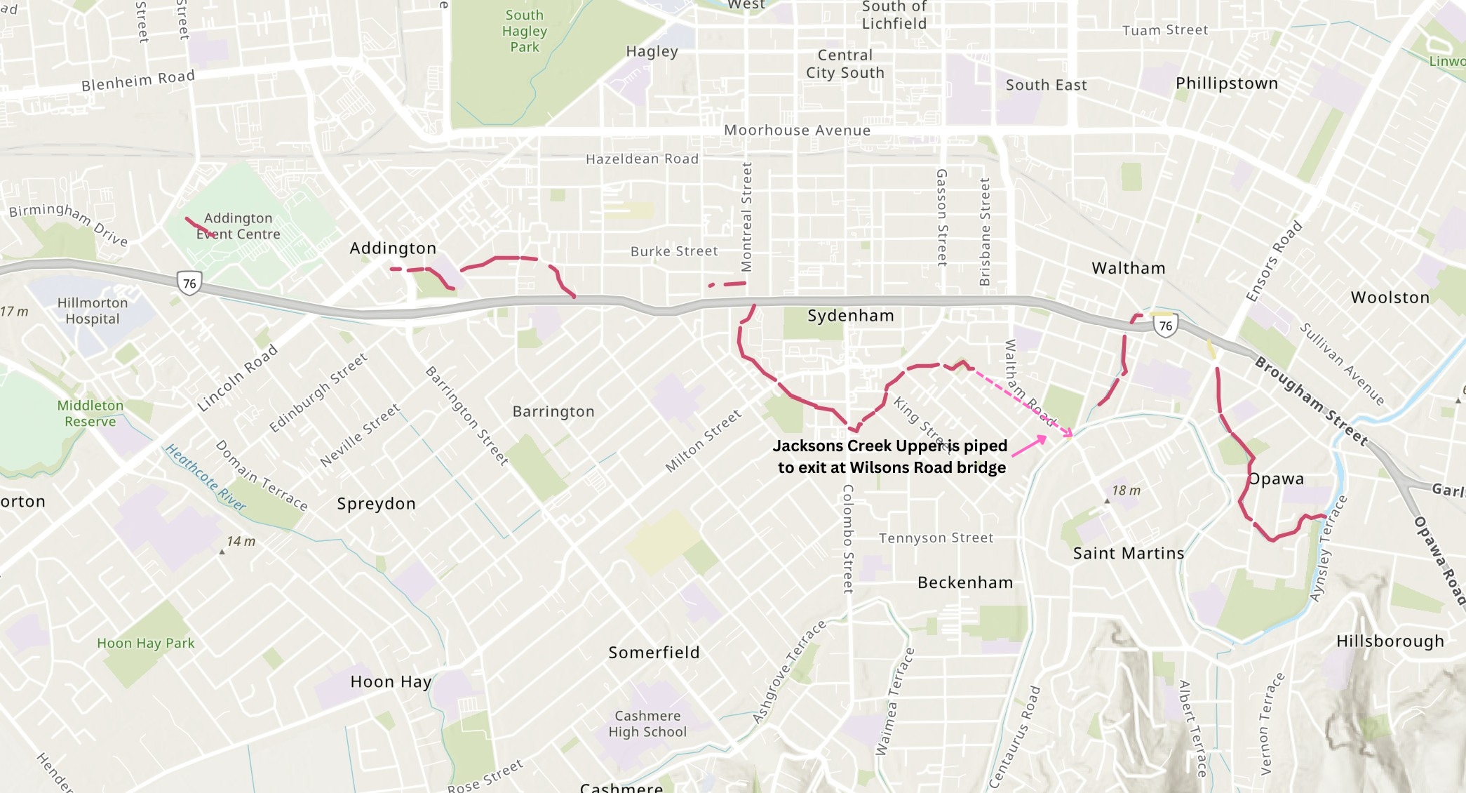
Jacksons Creek shown in red. Click to enlarge

About the waterway

The catchment of Jacksons Creek covers 810ha and contributes just under 10% of the total area of the Ōpāwaho Heathcote River catchment. Spring-fed by a number of small springs along its length, Jacksons Creek was an historically important waterway featured on all early maps its existence being an annoyance to early developers and drainage engineers.  The creek originally meandered very close to the Ōpāwaho Heathcote River in the vicinity of what is now the Waltham Pool and Waltham Park.  Christchurch Drainage Board annotated plans (see below) show that significant portions of Jacksons Creek Upper were placed in pipes between 1900 and 1940.

In 1930, the Austin Street section was covered and built over. This presaged the eventual severing of the creek likely to have taken place sometime between 1930 and 1940, probably as a result of flooding issues. The creek was severed at the intersection of Austin and Waltham Roads and redirected in pipes to empty into the Ōpāwaho Heathcote River at the Wilson Road bridge which it does to this day. During the 1980s, in response to frequent flooding within the suburb of Beckenham, this piping was enlarged to a 900 mm diameter stormwater pipe to improve the discharge rate.

Visionary plan

In 2018, WSP Opus was appointed by Christchurch City Council to produce a vision of what a future urban catchment in Christchurch should look like in 50 – 100 years. Based on the Vision and Values work delivered during 2016 , the intention was to provide a potential template for delivering the high-level aspirations identified within the Stormwater Management Plan documents.

Read JACKSONS CREEK CATCHMENT – A POSSIBLE FUTURE 2018

Where it joins the river

Jacksonupper2
The confluence of Jacksons Creek Upper at Wilson Street bridge. Definitely not fish friendly! Click to enlarge
Jacksonlower1
Confluence of Jacksons Creek Lower at the end of Louisson Place with the creek passing under the walkway into Hansen Park. Click to enlarge.

Jacksons Creek Upper

Views of Jacksons Creek from its source in Addington Raceway until it reaches the Ōpāwaho Heathcote River at Wilsons Road bridge.

Img 2702
Jacksons Creek begins here as a drainage swale at the southwestern end of the Addington Raceway inner grounds. Click to enlarge
Img 2722
Having been piped from Addington Raceway under Lincoln Road, the creek appears very briefly in a neglected open-air section behind a CCC utility building beside the petrol station on the corner of Lincoln and Barrington Street before being piped under the latter. Click to enlarge
Img 2704
The creek emerges from under Barrington Street to run around the edge of Addington Park in a largely intact half-round channel. Click to enlarge.
Img 2705
Part of the Addington Park section has been naturalised as in this view just before it is piped under Sacred Heart School. Click to enlarge
Img 2707
The creek's passage under Spencer Street is marked by this inlay on the road outside the Sacred Heart Church. Click to enlarge
Img 2708
A plaque inlaid into the footpath indicates the creek as it emerges from under Spencer Street and continues between properties in a concrete channel. Click to enlarge
Img 2709
While the creek itself is well-maintained in this area, it is not treated well by its neighbours. Here it disappears beheanth Collins Street. Click to enlarge
Img 2721
Neglect on one side, crowded out on the other. The creek emerges from Collins Street and heads between properties towards Addington Square. Click to enlarge
Img 2710
The creek emerges beside the driveway of 32 Ward Street and continues in a 190m open-air section between properties. Click to enlarge.
Img 2723
The creek forms the boundary of the Addington Seventh Day Adventist Church and Lalaga Preschool before entering a 750m section of piping that takes it roughly following along beside Brougham Street before appearing again on Antigua Street. Click to enlarge.
Img 2695
After 750m of piping along Brougham Street, the creek emerges ibriefly in this recently enhanced open section behind new buildings at 44 Antigua Street. Click to enlarge
Img 2696
An ugly short open-air section beside 19 Montreal Street. The grating is the beginning of a piped section under both Montreal and Brougham Streets to the grounds of Nazareth House. Click to enlarge
Img 2694
The creek appears from under Brougham Street and enters the gardens of Nazareth House. Click to enlarge
Img 2693
The creek as it passes through the gardens of Nazareth House to the west of Sydenham Park. Click to enlarge
Img 2692
The creek emerges from under Milton Street into Bradford Park. Click to enlarge
Img 2691
The half-pipe bed ends ends partway through Bradford Park and enhancement with boulders is encountered. Click to enlarge
Img 2690
As it leave Bradford Park for Colombo Street, the stream passes through an enhanced area that includes a footbridge with Jacksons Creek named in the ironwork. Click to enlarge
Img 2688
At the rear of 234 Colombo Street, the stream enters a ppe to pass under the property and the road. Click to enlarge
Img 2689
Having just passed under Colombo Street, the stream forges past the Essie Summers Retirement Village in a beautiful native-planted setting. Click to enlarge
Img 2687
The stream departs Southhampton Street for King Street. Half-round concrete base. Click to enlarge
Img 2684
Tyres form the retaining wall of the neighbouring property as the stream dives under King Street. Click to enlarge
Img 2683
Naturalised stream as it enters Jacksons Creek Park having passed under Huxley Street. Click to enlarge
Img 2682
A lovely enhanced section as the creek leaves Jacksons Creek Park to pass diagonally under Cameron Street. Click to enlarge
Img 2680
Naturalised stream in Cameron Reserve (see story below) Click to enlarge
Img 2678
As the creek leaves Cameron Reserve it passes through this awful utilitarian grating to enter the pipe that takes it from here to its exit at the Wilsons Road bridge.
Jacksonupper2
The confluence of Jacksons Creek Upper at Wilson Street bridge. Definitely not fish friendly! Click to enlarge

Jacksons Creek Lower

Views of the lower section of Jacksons Creek. After being diverted to the river at Wilson’s Road bridge, springs under Waltham Park cause it to resume nearby until it reaches the Ōpāwaho Heathcote River at Hansen Park.

Img 2718
The creek has already started flowing in a concrete channel here at the end of Westby Street. Click to enlarge
Img 2677
The creek just as it is about to disappear under York and Brougham Streets. Click to enlarge
Img 2667
How does such a short open section survive development all around. This section where the creek emerges from under Brougham Steet and then immediately dips under Opawa Road in what used to be a caravan sales yard. Click to enlarge
Img 2668
Behind the tyre and car repair shops on the cnr of Opawa Road and Brougham Street the creek passes through a neglected patch of open embankments. Click to enlarge
Img 2666
Beside a patch of open ground at the intersection of Brougham Street and Ensors Road the creek passes through in a broken channel unseen. Click to enlarge
Img 2669
Having passed under the roundabout at Ensors Road and Opawa Road, the creek passes through private properties including this at 82 Opawa Road. Old concrete channel often broken and silted over. Click to enlarge
Img 2715
Parts of the section that passes through private properties indicate the the creek is appreciated. Click to enlarge
Img 2716
The creek about to dive under Cholomdeley Avenue. The creek bed is several metres below the road. Click to enlarge
Img 2671
Concrete walls on this section as the creek passes through the grounds of Risingholme Park. Click to enlarge
Img 2713
The creek passes under Ford Road, the culvert largely filled with sediment in a bed which shows the remnants of old concrete channel. Click to enlarge
Img 2714
The deep ravine with silted cluvert continues as the creek passes under Hawford Road. Click to enlarge
Img 2673
As the creek passes through the culvert under Hawfoard Road, the roading people have gone out their way to indicate the creek beneath. There is a plaque as well. Click to enlarge
Img 2717
At the end of Newbry Street the creek passes into an open area in a narrow channel. Click to enlarge
Img 2675
The creek broadens as it become more tidal just prior to the confluence. Click to enlarge
Jacksonlower1
Confluence of Jacksons Creek Lower at the end of Louisson Place with the creek passing under the walkway into Hansen Park. Click to enlarge.

Historical maps

1930s
Drainage Board plan from late 1930s.. Click to view original.
1948
A street map dated to circa 1948 with the waterways that contribute to the river clearly marked. Click to enlarge
1908
Drainage Board plan accompanying a contract to lay a 15" semi-circular concrete invert (pipe) in Jacksons Creek Lower dated 1908

Naturalising the creek

During the 1990s, the Christchurch City Council commenced a series of river enhancement projects throughout the city, reflecting a change in attitude on managing urban streams. The original Drainage Board attitude that “drainage is everything” was drastically revised and a new focus placed on a stream’s ecological functions. Projects to improve the aesthetic and ecological values of streams were approved including the enhancement of two sections of Jacksons Creek that passed through reserves in Waltham – Cameron Reserve and Jacksons Creek Park.  Enhancement was completed in 1995.

In 1999, NIWA did a follow-up survey to see what changes the enhancements had made to the ecology of the stream in these reserves.  Read NIWA’s results.  You can see the most recent view of the enhancements below.

Note: Rachel Barker who at the time of the enhancement programme was involved as a member of the Christchurch City Council Parks & Waterways Unit, is a leading member of ŌHRN.

B4natjc
The creek in Cameron Park before enhancement in 1995. Note the concrete lining of the channel. Click to enlarge
4ypostnatjc
The same part of Jacksons Creek four years later in 1999. Click to enlarge
30ypostnatjc
The same area 30 years after enhancement. Exotic grasses in a mown park have caused encroachment of the bank and reduction in native plantings. Click to enlarge