
When a rain event at the end of April 2025 deposited over 140mm of rain on Christchurch over two days, what would have previously been inevitable flooding of houses in Beckenham, Opawa and Woolston was largely averted by the considered actions of just a couple of City Council staff.

While the ponds were primarily designed to prevent flooding, sediment retention is expected. It is evidenced in the picture above taken in Te Kuru after the recent rain.
Obviously, the decision of successive City Councils over 20 years to propose, design and build retention ponds in the headwaters of the Ōpāwaho Heathcote River actually made it possible to avert flooding in these large rain events. The large dollops of funding required to acquire the land and undertake the earthworks were well-spent given that no houses were inundated in this recent 1:100year event.
While the ponds continuously slow the rate of flow of stormwater into the river from surrounding land, retention of the water to the maximum of the ponds’ design requires the closing of a series of flood gates in each of the ponds: Te Kuru wetlands in Halswell, the Sparks Road Wetland by Hendersons Road, the Cashmere/Worsley Valley Ponds and Dam at the foot of the Cashmere Valley, the Wigram Ponds beside the Ngā Puna Wai sports hub and the Curletts Stream Basin across Curletts Road from the Canterbury Agricultural Park.
Automation of the operation of flood gates in each of these ponds is a work in progress. Until it is complete, the entire holding back of the flood relies on the knowledge and experience of less than a handful of CCC staff working many of the gates directly. At first glance, it appears to be a simple task – just close the gates when it starts to rain and open them when it is finished. Job done! However, just consider the following variables as an insight into the difficulties that the CCC staff face.
It rarely rains as forecast Weather forecasting is a matter of probabilities. That forecasters often get it wrong despite the power of the computers that they use tells us that it is difficult to predict weather reliably, especially in New Zealand which is narrow and lies along the path of variable interaction of weather masses. The forecast may be for a short, light event but what happens when it turns out to be heavy and lengthy instead? The rain may fall more heavily on the plains than on the hills, or vice versa. Relying on the forecast to provide predictive inputs to decision-making about the ponds is asking to get it wrong.
Flow from different topographies The retention ponds fill at different rates and all have widely different capacities. They take their inputs from different typographies. The Wigram and Curletts ponds take mostly surface water from Wigram and Hornby – developed areas with relatively high areas of impervious surface – roads, carparks, houses, shops and factories. Te Kuru takes flow from the Hoon Hay Valley – most agricultural land with some housing. It is also taking increasing stormwater flow from the new Halswell housing developments. Cashmere Dam and Valley ponds take flow from the Cashmere Valley – hilly, tussocked and forested land that includes the Christchurch Adventure Park and housing developments both above the valley and within it.
The gates that control the release of retained water from the Cashmere retention ponds. These gates are normally open.
When to close, when to open When it rains, should the ponds be immediately closed so that as much water as possible is retained from early in the event, or should closing of the retention pond gates be delayed until the flow in the river reaches a particular trigger level? If water is retained early, capacity is not available later if the event is a substantial or longer duration one. If the closing of the gates is delayed, the surge of water entering the river from all headwater sources may cause the flooding that would otherwise have been prevented by an earlier closing. In all of this, what is the effect of opening the Woolston barrage so that the river flows directly through the Woolston Cut, and what effect does the tide have on water levels?
What order of release? In what order should the ponds release their stored water after an event so as to maximise further storage capacity in the event that a second rain event follows swiftly after a previous one? Should the Cashmere Dam, which is higher up the valley, be closed before or after the lower retention ponds have filled? Is the dam a backstop to the retention capacity of the ponds to be only used when the ponds’ capacity has been reached, or does the dam get filled first leaving the ponds to be the final stage of storage capacity?
How much to release? How can the rate of water flowing down the river be safely gauged so that no flooding occurs and yet the maximum rate of outflow from the retention ponds can be achieved. Draining the ponds as quickly as possible is important, not only to restore capacity for future rain events but also to create an important flushing effect to remove sediment and other contaminants from the river.
What actually happens If you look for certainty, there is little to be found. The real answer is that it all depends on a number of factors which includes the actual rate of rainfall as it is occurring, the actual river level as it is measured, an eye on the forecast, an eye on the tide and reliance on information from previous events – in other words, the experience of the CCC staff.
Measuring the flow of water in the river There are a couple of certainties one of which is the data that is sensed continuously by the CCC hydrometric network. At the end of 2024, this set of data sensors included 37 sensors for water level across the city and 28 for rainfall. Also feeding data into the CCC network is the Buxton Terrace water level site maintained and operated by Environment Canterbury.
Triggers The release of stored water in the retention ponds relies on staff evaluation of the current overall situation but also on the downstream trigger river levels of 11.6m at Buxton Terrace, 16.6m at Ferniehurst Road bridge and 21.3m at Lincoln Road bridge. These levels are used for guidance, not as a firm rule and are also subject to occasional reviews following large events. The Woolston barrage is normally closed but opens automatically if one of two trigger conditions is met:
- The river level at Buxton Terrace exceeds 11.0m, or
- Rainfall at Sparks Road exceeds 10mm within 12 hours.
The barrage automatically closes 24 hours after these conditions are no longer met. Contrary to widespread belief, even at high tides the extra flow capacity from opening the barrage results in lower flood levels upstream than if the gates were closed at high tide during a rainfall event.
A picture of the flow You can find publicly available river flow data here on the Environment Canterbury website. Looking at the graph (see below) of the flow of the Ōpāwaho Heathcote River at Buxton Terrace is illustrative. The graph below shows the flow at Buxton Terrace from 28 April – 16 May. The rate goes from a baseline flow just over 1m3/sec and rises steeply to an impressive peak of 17.5m3/sec before declining over two weeks back to its baseline flow. The steep slope of the graph of the initial event and post-peak period is indicative of both the intensity of the rain that fell and that the city is not a “sponge city” – there is a large impervious area from which the water drains relatively quickly. Each of the mini peaks that occur during the days after the peak indicates the opening or further opening of one or more of the control gates on the ponds. The gentle slope of the graph from 2 May to 8 May indicates the work of the CCC staff endeavouring to maximise the draining rate of the retention ponds.
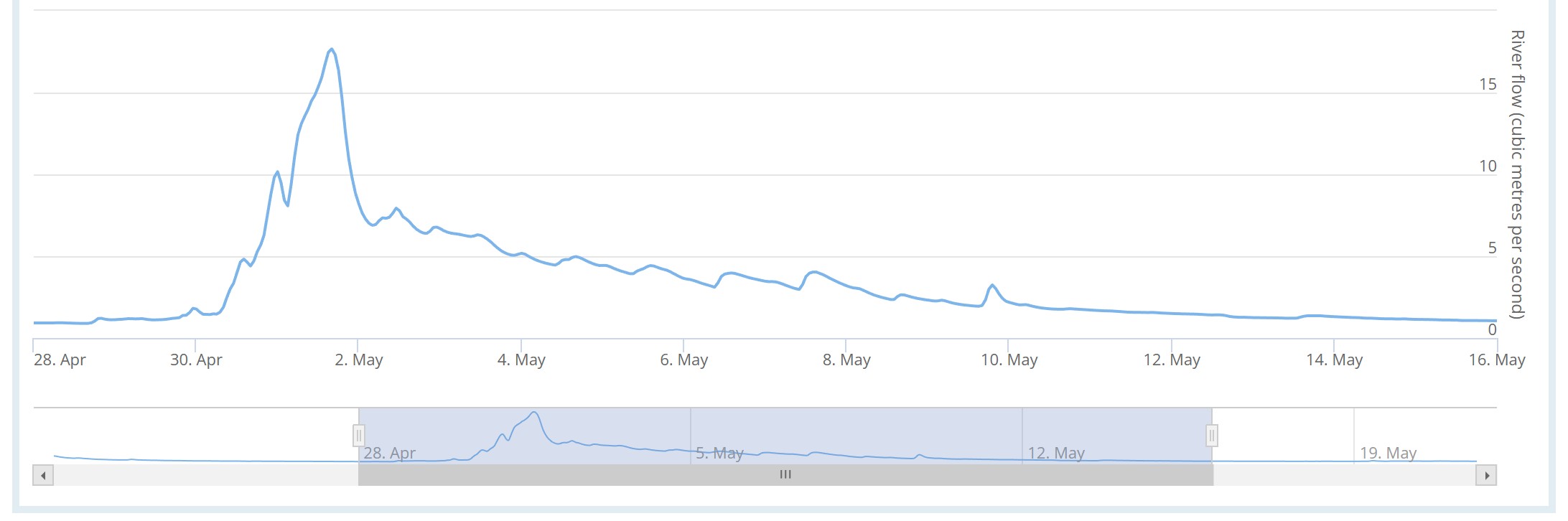
Graph of the flow rate at Buxton Terrace, 28 April – 14 May (Source: Environment Canterbury)