About the river

Location

The Ōpāwaho Heathcote River extends for approximately 25.5 km from south-west Christchurch to its mouth at Te Ihutai (Estuary of the Ōtākaro Avon and Ōpāwaho Heathcote Rivers) in Ferrymead. The catchment covers approximately 103 km² in the south of the city stretching north to south from the edge of the Central Business District to the top of the Port Hills and west to east from Ruapuna Park to the Ihutai Avon-Heathcote Estuary.

Naming

European settlers took little notice of the mana whenua names for the river. The settlers’ name for the river came from Sir William Heathcote, Secretary of the Canterbury Association, in London.  At the time that it was named in Sir William’s honour, the river was in many places a meander through swamp and surface waters. It is therefore not surprising that the early settlers believed that the river took a right-angled turn where it met what is now Cashmere Road.

When the Cashmere Valley was drained to reveal the stream running through it, the landowner of the time, Sir John Cracroft-Wilson, named the revealed waterway Cashmere Stream. This set up the currently accepted but unofficial naming of the waterways as shown below.

European Heathcote River

However, for mana whenua, the waterway which provided food and transport over to Te Waihora (Lake Ellesmere) had the singular name Ōpāwaho, a reference to the outpost pā sited on the riverbank at the current site of the Opawa rail bridge.  Joining Ōpāwaho at the confluence was a separate waterway called Waimōkihi.  Waimōkihi refers to the area and Ōmōkihi refers to a pā site located in what today is called Centennial Park. Waimōkihi also denotes the probable usage of watercraft made of intricately bound raupo reeds.  The mana whenua naming of the waterways is shown below.

Māori Heathcote River

This difference in the naming of waterways produces issues when it comes to dual naming.

  • Naming the waterway from the coast to the confluence is straight-forward: Ōpāwaho/Heathcote River
  • Confluence to Cashmere Valley: Ōpāwaho/Cashmere Stream
  • Confluence to Nga Puna Wai and beyond: Waimōkihi/Heathcote River

If only the settlers had been more willing to accept mana whenua names for geographical features, this situation would not exist.  From a geographic point of view, it is all in fact one waterway system. However, the water flowing downhill from the springs at Nga Puna Wai to meet the main stem of the river running along the base of the Port Hills means that the mana whenua naming convention makes more sense than the European one. Ngā Pou Taunaha o Aotearoa , the New Zealand Geographic Board has yet to be asked to officially determine names for the waterways.

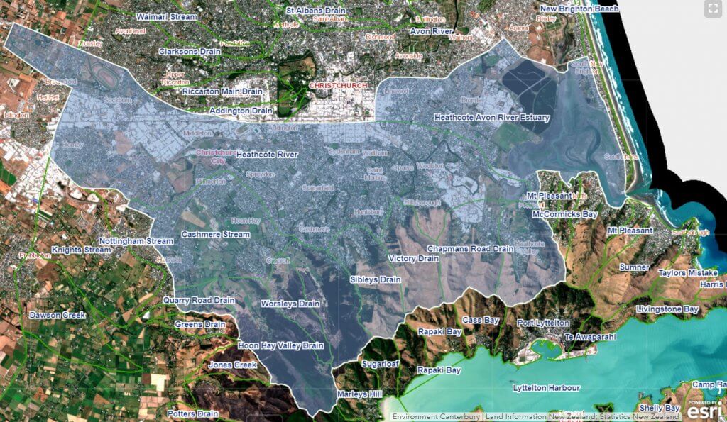
River Catchment

A catchment basin is an area of land where all surface water from rain, ice or melting snow converges to a single point at a lower elevation, usually the exit of the basin, where the waters join another body of water.

blank

Ōpāwaho-Heathcote River Catchment information. Click image to enlarge.

The catchment of the Ōpāwaho-Heathcote River drains an area of approximately 100 square kilometres of land within the Christchurch city boundary. It includes nearly one-third hill catchment and an area of rural land in the south-western part of Christchurch that is decreasing over time due to residential development.  It is slow flowing and meandering and has a number of tributaries that include both natural streams and human-made drains.

The river begins in the area of Templetons Road, and it also receives wet weather flows from as far west as Pound Road. It flows through Hoon Hay and Spreydon, then it meets the Cashmere Stream before flowing through Cashmere, Beckenham, St Martins, Opawa and Woolston. It drains into the Avon-Heathcote Estuary/Ihutai at Ferrymead. Seawater intrusion extends to a point just above the Mackenzie Avenue footbridge.

Where does the water in the river come from?

Water in the Ōpāwaho-Heathcote River comes from two different sources; springheads which are connected to confined aquifers, and rainwater running off the surface of the land into tributaries.

Confined aquifers are stores of water trapped in layers of gravel by layers of mud or clay that seal the water in. If the water in a confined aquifer runs into a dead end because of barriers such as the rocks of Banks Peninsula or a wall of clay, the pressure builds up, a bit like putting your finger on the end of a running hose. This pressure forces the water up to the surface. When the water erupts through the surface it is called a spring. Springs are recharged by water travelling very slowly underground from the Alps to Christchurch plains, and by rain soaking into the ground.

blank

Click to image to enlarge

Springs contributing to the Ōpāwaho Heathcote River are located mostly in the Halswell, Oaklands, Wigram, and Hillmorton. However, two lovely springs can be found in Beckenham Park and Ernle Clark Reserve. You can read more about the springs that feed the river here.

Prior to the development of Christchurch, there are more than 400 named waterways. Now there are only 356 km of open waterways (less than 1 km per named waterway!), and 500 km of underground pipes which are used to divert and drain the surface water away.

blank

One of the source springs of the Ōpāwaho-Heathcote River in Hoon Hay

The major natural tributary into the Ōpāwaho-Heathcote River is the Cashmere Stream.  Other tributaries were often turned into open drains. Examples are Haytons and Curletts Road streams, which feed into the upper reaches of the Ōpāwaho-Heathcote. For most of their length, these tributaries are straight, timber-lined drains vulnerable to industrial pollution. Other tributaries include Steamwharf Stream and Coulings Stream. Dozens of small creeks running off the Port Hills are also diverted into stormwater network or drains.

The biggest difference between Ōpāwaho-Heathcote River and the Otakaro-Avon River is that the Ōpāwaho-Heathcote River receives water running off the Port Hills, which tends to be loaded with fine soil particles (sediment).

Natural History of the river

Beckenhamponds

Beckenham Ponds

Christchurch was once a mosaic of wetlands and small waterways formed by the past actions of the Waimakariri River and its underground aquifers.  Prior to the wetlands being drained and the urbanisation of Christchurch city, the habitat the river passed through was abundant in flax (harakeke), toetoe, raupo, tutu and ferns and was dotted with ti kouka (cabbage tree). The river corridor was low-lying and very wet. The only remnant of the marsh that remains today is the Beckenham Ponds, formed from natural springs in Beckenham Park.

blank

Kōura (native freshwater crayfish)

Prior to extensive modification for urban and industrial development, many aquatic species would have flourished in Christchurch waterways. Tuna (longfin and shortfin eels), freshwater fish such as bullies, inanga, kowaro (Canterbury mudfish), kākahi (mussels), kōura (crayfish), and estuarine fish such as kanakana (lamprey) and pātiki (flounder) were important food sources for Maori. They are still found in the river, but in much smaller numbers than pre-European settlement.

Barriers to fish migration – a usual part of our native fish breeding cycle – all contribute to declining fish populations. Weirs, confinement of waterways (especially tributaries) into pipes or boxed culverts, and specifically in the Ōpāwaho Heathcote River, the construction of the tidal barrage in Woolston, are serious impediments to fish passage and a healthy waterway.

Mana Whenua River History

Christchurch was once a mosaic of wetlands and small waterways formed by the past actions of the Waimakariri River and its underground aquifers. The river passed through habitat that was abundant in flax (harakeke), toetoe, raupo, tutu and ferns and was dotted with ti kouka (cabbage tree). The river corridor is low-lying and was historically very wet.

The wetlands draining the Ōpāwaho Heathcote River were called Te Kuru and the upper reaches of the river at Spreydon was called Wai Mōkihi after a smaller pā located there called Ō Mōkihi, which means meeting place of the raupo rafts. Waitaha people would have known the Ōpāwaho river area first, and then came Kati Mamoe and Ngāi Tahu.

Ō-pā-waho means Outpost pā. It refers to a pā sited just downstream of the present Opawa Road Bridge at what is now the intersection of Judges St and Vincent Place. The Ōpāwaho pā was used by Ngāi Tahu, who used the Ōpāwaho River to travel between Tuahiwi, Kaiapoi and Te Pātaka o Rakaihautu (Banks Peninsula). Water plays a unique role in the traditional economy and culture of Ngāi Tahu. The most direct physical relationship that Ngāi Tahu have with water involves the protection, harvesting, and management of mahinga kai. The term mahinga kai is a broad term that refers to natural resources, particularly the way resources are gathered, the places they are gathered from, and the resources themselves. It includes fish such as tuna and inaka, materials such as harakeke, and paru, which are used for dyes and entire areas such as the Ihutai (estuary) and Orua Paeroa (South New Brighton) and its sand dunes and wetlands.

blank

Canterbury Plains from an 1855 lithograph by Edmund Norman

Near Wigram the Ōpāwaho River is close to the headwaters of the Halswell River. Ngāi Tahu travellers used to drag their waka across this gap, or build provisional moihi from reeds, thus being able to travel by water from Waihora (Lake Ellesmere) to Ōtautahi (Christchurch).  The Ōpāwaho River was also an important mahinga kai, a source of plentiful food, especially tuere (blind eel) and kanakana (lamprey) and mata . The swamp forest around the river provided gathering grounds for water fowl and forest birds. Traps were regularly set for inanga (whitebait), pātiki (flounder) and tuna (eels).

In the 1800s Ngāi Tahu made unsuccessful attempts to have some sites in the Christchurch area made into mahinga kai reserves. They were effectively excluded from exercising their kaitiaki responsibilities in the development of the City and the management of the Ihutai catchment.

Longfin and shortfin eels, bullies, kanakana, inanga, kowaro (Canterbury mudfish), kākahi (freshwater mussels), kōura (freshwater crayfish), and pātiki flourished in Christchurch waterways prior to extensive modification by urban development. These were important food sources for Māori, and while most are still found in certain parts of the river, it is in vastly smaller numbers.

The signing of a Deed of Settlement in 1997 and the passage of the Ngāi Tahu Claim Settlement Act in 1998 provided confirmation of the ability for Ngāi Tahu to express its traditional kaitiaki relationship with the environment. In 2020, Ngāi Tahu lodged a statement of claim in the High Court seeking recognition of rangatiratanga over its awa and moana, to address the ongoing degradation caused by environmental mismanagement. The claim is to be heard in 2025.

European River History

When European settlers arrived, many crossed over the Port Hills on the Bridle Path and made their way down the Heathcote Valley, and crossed the river at several ferry points. The road from here to the settlement was one of the few well-made roads, and is what we know as Ferry Road. Rather than carrying all their goods over the hill, they were shipped around from Lyttelton in smaller vessels (known as a mosquito fleet) which plied up and down the coast. This involved crossing the precarious Sumner Bar without incident, before entering the Estuary and navigating the channels to the Ōpāwaho Heathcote River.

Dept of Survey Map 1978

Click to enlarge

At six to eight metres deep, the river was deeper than the Ōtakaro Avon and was important for shipping in the 1850’s. The sharp bends in the river and the wind from the hills and the swamp flats made navigation difficult. A towpath was created on both sides of the river where horses or bullocks were used to tow the boats up the river as far as Richardson Terrace. By the 1860s, up to 15 vessels were sailing up the river on a daily basis. It wasn’t a cheap exercise – it would cost almost as much to get goods from Lyttelton to Ferry Road as it would to freight the same goods from London to Lyttleton! However, once the railway to Ferrymead was opened in 1863 and the Lyttelton Railway Tunnel was opened in 1867, the role of the Ōpāwaho Heathcote River in transport diminished greatly.

In 1873 there were seven wool scours and five tanneries on the lower Ōpāwaho Heathcote River; by 1883 there were 11 of each. Subsequently, other industries gravitated to the Woolston area, notably a large gelatine and glue works and a rubber factory. The founding of Para Rubber, followed by the establishment of the Latex, Marathon and Empire factories made Woolston the centre of New Zealand’s rubber industry.

By the 1880s, the river was too silted to use as a trade route. In the space of just 30 years settlers managed to fill up a water channel that was 8 metres deep. The source of the silt was primarily from the de-forested slopes of the Port Hills, but another contributing factor was that the river was used as a sewer or drain for the industrial factories. By the turn of the 19th Century, nearly a quarter of New Zealand’s industrial activity was located in this area with all their waste being pumped into the river. Stinky!

It wasn’t until 1971 (that’s over 100 years of industrial waste!), when the Woolston industrial sewer was completed, that industrial wastewater was sent to the Christchurch wastewater treatment plant in Bromley instead of running into the river.  From a highly polluted, murky and unattractive lower reaches of the river and the Estuary, we now have a much healthier and cleaner river, but there is still a long way to go!

Ecological status of the river

Prior to European settlement, Māori would have viewed the river and estuary as a cornucopia or kete of riches, filled with birds, fish and other useful resources for their daily and seasonal use.  However, until relatively recently, European settlement meant disaster for the health of the Ōpāwaho Heathcote River. Although initially used for shipping purposes, its status was relegated to that of a drain or sewer conduit by a growing industrial and residential population. Until the aesthetics of amenity value overtook convenience in the mid-20th century, all manner of toxic chemicals, rubbish and sewerage were dumped in the river.

blank

Click to play video

Current monitoring by the Christchurch City Council indicates that the Ōpāwaho-Heathcote River has characteristics typical of an ‘urban river syndrome’. It has the worst water quality of any river in Christchurch.

For specific information about the ecological health of the Opawaho-Heathcote River, watch the video presentation ‘Recovery of the Heathcote River: Water Quality and Aquatic Ecology‘ by Christchurch City Council freshwater ecologist, Dr Belinda Margetts, presented at the Natural Environment Recovery Programme March 2015 (approx 10mins, Dr Margetts begins at 2:55min). Belinda’s presentation also includes comments on the impact of the 2011 earthquakes and the aquatic ecology of the Ōpāwaho Heathcote River.

blank

Click to play video

For an overview of the ecological health of waterways in Christchurch in general, watch this ‘Caring for our Urban Waterways‘ presentation also by Dr Belinda Margetts, presented at the Caring for Urban Waterways Forum 2016.

Characteristics of an urban river syndrome include:

  1. Water, unable to soak through the ground and recharge aquifers or rivers, instead runs along gutters and into stormwater drains, collecting pollutants and litter along the way.
  2. Riparian (river bank) vegetation is removed for building or other developments, or so that people can see the waterways. However, riverbank vegetation is important to help keep river banks stable and provide habitat for fish, birds and insects.
  3. Erosion of unstable stream banks.
  4. Large amounts of sediment can be washed into the waterway as a result of clearing vegetation, new subdivisions, or the building and extension of houses. This is especially relevant for the Ōpāwaho Heathcote River.
  5. A greater variation in river flows – much lower flows when there is little rain and much shorter,  sharper floods in times of heavy rain because the water runs off quickly rather than soaking into the ground and recharging aquifers. (See more details about flooding)
  6. Straightening of stream channels, culverting and piping of waterways decreases the amount of habitat available for invertebrates and fish.
  7. Pollution
  8. Excess nutrients. Nutrients are substances that provide nourishment essential for life and growth. Nutrients in waterways include nitrogen and phosphorus – e.g. from garden fertiliser dissolved in rainwater, or from farming activities. Too much of these nutrients can upset the balance of life in the waterway.
  9. Proliferation of invasive freshwater weeds.

Aquatic Plants

738ead62 6aa5 444d 870d D3d1fe549d5d

Reed Canary Grass invading the riparian areas of the river near Beckford Road

The Ōpāwaho Heathcote River aquatic plant life has changed significantly. The plants have changed from mainly filamentous green algae that floated in or on the water, to larger, leafy, introduced plants such as Curly-leafed pondweed (Potomogeton crispus)Oxygen weed (Egeria densa),  Canadian pondweed (Elodea canadensis) . These are attached to the bottom and tend to clog up the river, slowing down the water flow and holding sediment in place so that it is no longer flushed out when there is a flood. All introduced plants are pest species which have major impacts on indigenous plant biodiversity, hydrogeneration, irrigation, flood protection and recreation.

Riparian Plants

Stream restoration groups are playing a vital part in restoring the riparian vegetation which would have been present in various gradients along the river banks from source to sea.

Currently, the greatest threat is from Reed Canary Grass which has made an impact on the riparian vegetation in the lower third of the river.  White Poplar (Populus alba) is also a developing problem in areas where it has established itself on the riverbank.

King George V Reserve in St Martins/Beckenham is an excellent living example of a restored riparian ecosystem showcasing the plant species which would have been present on these stretches of the Ōpāwaho Heathcote River banks prior to human habitation. The area is planted in zones of terrace slopes of tōtara (Podocarpus totara) and matai (Prumnopitys taxifolia), woodlands of kānuka (Kunzea spp.), river levees of kōwhai (Saphora spp.)houhi ongaonga (Hoheria sexstylosa),  and houhi puruhi (Hoheria angustifolia), flood plain forest with kahikatea (Dacrycarpus dacrydioides) and pōkākā (Elaeocarpus hookerianus) swampland  planted with pūrei (Carex secta)harakeke (Phormium tenax) and ti kōuka (Cordyline australis).

blank

King George V Reserve

Fauna of the river

The invertebrate fauna of the Ōpāwaho Heathcote River are typical to that found in other urban streams. The macroinvertebrate community is dominated by worms – primarily oligochaete (segmented) worms,  two species of snails – New Zealand mud snail (Potamopyrgus antipodarium) and the introduced Physella acuta two kinds of crustaceans – seed shrimp (ostracods) and the freshwater amphipod (Paracalliope fluviatilis) – and midges.

blank

Kōura

Different species of fish including bullies, introduced trout, tūna (eels). pātiki (flounder) and inaka (whitebait) have all been observed in the Ōpāwaho Heathcote River. Kākahi (freshwater mussels) and kōura (freshwater crayfish) are living in Cashmere Stream.

Img 0793

Pāpango duck and ducklings near Cashmere Stream

There are now more birds and more kinds of birds than there were in the mid-1980s, largely due to the habitat restoration work that was undertaken in the early 1990’s in the lower Ōpāwaho Heathcote River. Pāpango (scaup), pukeko, native ducks, cormorants and gulls are all present.

Sediment

After a heavy rainfall, the Ōpāwaho Heathcote River very often looks muddy or brown. This is due to sediment, which is tiny particles of rock or soil suspended in water, being deposited into the river. Excess sediment in the Ōpāwaho Heathcote River is a problem because it alters the habitat that many freshwater insects, fish and a number of birds species require to thrive.

blank

Sediment where the Cashmere Stream meets the Heathcote River, after heavy rain in 2014.

Prior to European colonisation, the wetlands and vegetation along the side of the Ōpāwaho Heathcote River and the forest growing on the hillsides would have ensured that this sediment loading was minimal. Removal of hill vegetation, farming, and urban development on the hills significantly increased the sediment load to the Ōpāwaho Heathcote River and its major tributary, the Cashmere Stream.  Despite strict consent conditions for developers, sediment loading into the river is still a persistent issue and a major threat to the health of the waterway.

The greatest proportion of sediment entering the river does so from the Cashmere Valley where the Adventure Park, residential sub-division, forestry operations and roading all conspire to create pathways for overland stormwater. that creates sediment loadings.

Pollution

Pollution is caused when substances (usually made or concentrated by human activity) contaminate the natural elements, such as air, land and water. Water is polluted when chemical, biological or physical material gets into fresh or ocean waters in amounts that do not occur naturally. Raised levels of contaminants such as heavy metals affect the quality of the water and the health of the plants and animals that live there. In cities such as Christchurch, these pollution problems are made worse by many hard, surfaces that do not absorb water (e.g. roads, car parks). When it rains, the water runs quickly across these surfaces, washing contaminants into our waterways unless it is treated first by retention in a filter basin or swale.

blankContaminants can include:

    1. Brake pad dust and rubber from vehicle tyres.
    2. Metals such as lead, copper and zinc, some of which come from roofing materials
    3. Fine particles of chemicals from industrial processes or from vehicle exhausts, which drop out of polluted air or are washed out of polluted air when it rains.
    4. Chemicals that collect on impervious, hard surfaces. Examples include oil that leaks from cars or trucks onto the roads, polycyclic aromatic hydrocarbons (PAHs) from the use of tar seal, detergents used when people wash their cars on their driveways, or paint chemicals that get into the stormwater system when people wash their brushes outside.
    5. Faeces from mammals (such as dogs, hedgehogs,  possums) and birds. Too much faecal matter in the water means that there are likely to be pathogens present in the water. The amount of faecal matter in the water is measured by the number of E. coli bacteria (short for Escherichia coli) per 100 ml. This measurement is used to decide when it is safe to drink the water, eat shellfish from the water, or swim. Faeces can also enter Christchurch waterways in times of high rainfall events, where stormwater enters the sewerage network and causes it to overflow.
    6. Chemical spills. Nowadays, chemical spills are usually accidents. An example of a chemical spill was in 2008 when blue ink was spilled into the Ōpāwaho Heathcote River.  Some chemical spills can remain invisible and only become obvious when the river smells (as happened when diesel was spilled into the headwaters of the river in 2005) or when plants and animals start to die as happened in 2023 when thousands of fish perished following the dumping of a spray containing toxins. All of these contaminants can affect the environment for a very long time. In Christchurch, these contaminants get into our rivers and may eventually end up in the sediments of the Avon-Heathcote Estuary/Ihutai.
    blank

    Floating litter collects at the barrage on the Woolston Cut

    Most of the time, these contaminants are below guideline values in the city’s rivers. However, in places with a relatively dry climate such as Christchurch’s, pollutants can build up over long, dry periods and run into the waterways in high concentrations the next time it rains. This is usually known as the ‘first flush‘.
    Haytons Stream is currently a pollution ‘hot-spot’ in the Ōpāwaho Heathcote catchment.

Flooding and salination

Much of Christchurch used to be wetlands, which provided a buffer against floods and droughts by acting a bit like a sponge which soaks up water at times of high rainfall and releases it slowly after the rain has stopped. Since 1850, most of the wetland “sponges” had been drained and cleared as Christchurch city has grown, but the water that they held still needs to go somewhere if it can’t get down the streams. Water runs very quickly off urban areas with their many impermeable (hard) surfaces such as roofs, driveways and roads.

blank

Riverlaw Terrace beside the flooded Ōpāwaho-Heathcote River in 2017

As Christchurch City grew over time and surface water volumes increased during heavy rain events, flooding became a significant issue in the lower Ōpāwaho Heathcote River in the 1970s, particularly in Clarendon, Richardson and Aynsley Terraces. In response to this, the City Council constructed the Woolston Cut, which cut a 450m straight line from one end of a loop in a lower part of the river to the other, with the aim to drain as much water away as quickly as possible. Opened in 1986, it became evident by 1988 that the Woolston Cut was having a significant negative environmental impact on the river. Salinated water was intruding further up the river, changing the soil structure of the river banks, which in turn weakened and collapsed, while also killing trees and changing habitat. Burrowing crabs also contributed to damage to the banks.

blank

Ōpāwaho-Heathcote River crossed by Brougham St , left, and Opawa Road.
5 March 2014, (Flooding aerials flight, Graham Harrington, Senior Surface Water Planner Christchurch City Council/ David Alexander, PhotoSouth Photographers.)

A tidal barrage was built by the City Council in 1993 at a cost of $1.5 million. It was designed to direct the river through the loop when the river is at a normal volume of flow. When the river floods, the barrage opens temporarily and allows the excess flood water through the Cut as well as the loop. This has helped to reduce the flow of salinated water up the river.  The Council also established Lower Heathcote Environmental Enhancement Programme, planting native species along the river banks to help stabilise the banks.

More recent flood management techniques include the construction of flood retention basins by the Christchurch City Council in the upper reaches of the river (e.g. Eastman, Wigram and Hendersons basins) and the Cashmere Valley Dam. Instead of immediately flowing into the river, water is instead held in ponds or behind the dam to be released when the rainfall ends. As a result, floods in the Ōpāwaho Heathcote River now have lower peaks.