
Our Urban Forest Plan for Ōtautahi Christchurch, adopted by the City Council in 2023, is already changing the look of parks and reserves within the city as the dedicated tree-planting team within the Council gets into the task of ramping up the percentage of canopy cover. But how will the river be planted?
If you are not aware of the Urban Forest Plan you can read about it here. Importantly, the majority of the trees being planted by the City Council under the Urban Forest Plan are native species which will, in time, provide the vital islands of food and habitat for native birds that will bring them back to our city. The planting of more native species will also move us a little way away from the danger posed by the “extinction of experience”, a concept that we previously outlined.
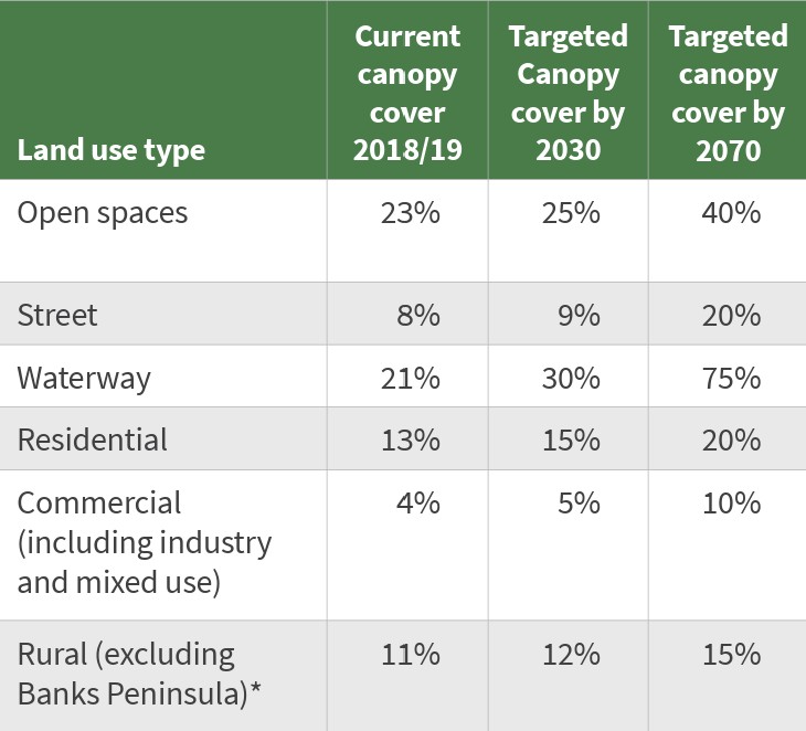
Canopy cover by Land Use Type
As a breakdown by land use type indicates, the greatest increase in canopy cover to be brought about by the Urban Forest Plan is expected to be along waterways, which is great news for the rivers of Ōtautahi Christchurch. More trees mean more shade, leading to cooler water and less weed, meaning improved river health – so long as we keep contaminants out of the water.
Even before the advent of the Urban Forest Plan, community groups and concerned individuals have been planting native trees, shrubs and grasses in reserves and in riparian areas of the Ōpāwaho Heathcote River to improve the biodiversity of these areas, to provide food and habitat for birds and to reduce sediment flow. In fact, these actions are the backbone of the hands-on work of the Network throughout the catchment. Evidence of new community planting is increasingly everywhere you look along the river.
Along with a handful of complaints from residents about potential loss of river views, implementing the Urban Forest Plan has caused the Council to review the legal planning basis for these community planting efforts along the river. With the exception of a couple of reserves that have approved landscape plans, most previous planting action along the river has been Council-supervised by Community Partnership Rangers, but it has not been formally approved and has not been part of a rationalised planting plan for the whole river.
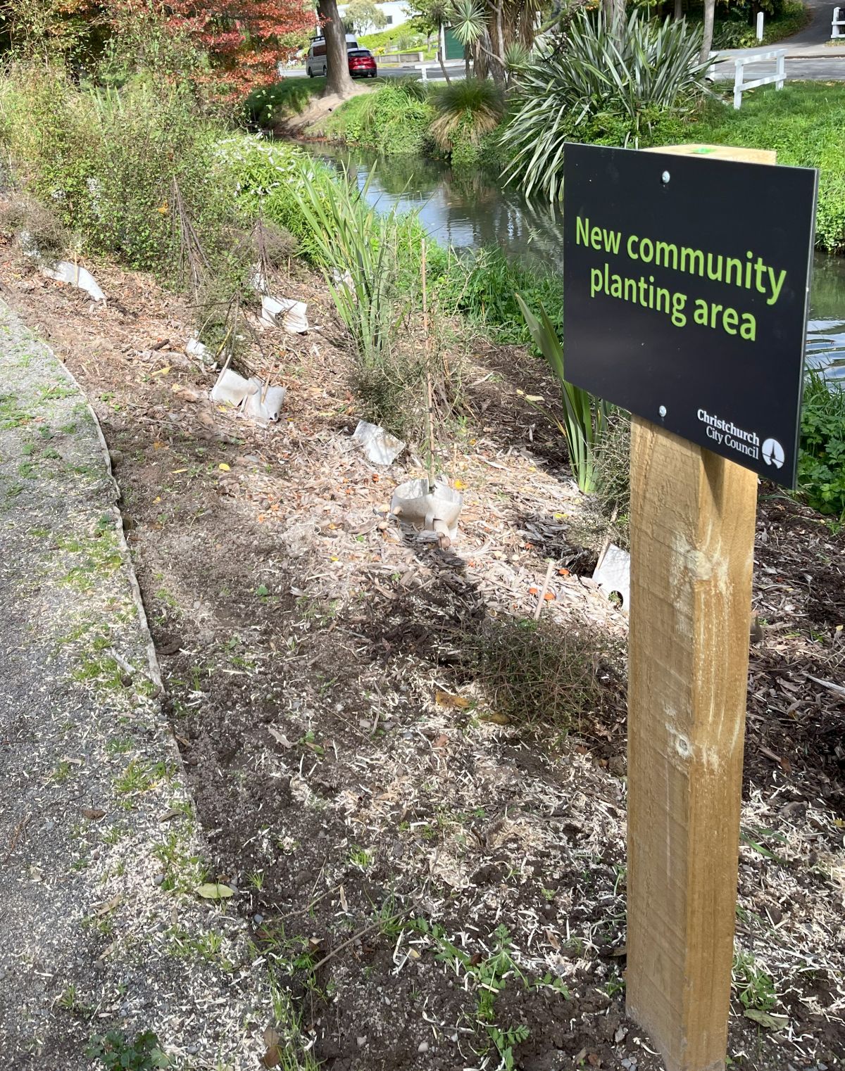
New community planting area in Beckenham
The final decision-maker on any action that significantly affects a city park (and that includes river banks) is the appropriate Community Board. Thus, all landscape and/or development plans for parks or the banks of the river must receive the prior, formal approval of the appropriate Community Board.
The exercise of obtaining the consent of Community Boards for future planting along the river corridor, and to bring past planting within the approval regime, has required the CCC Urban Forest Manager, Toby Chapman, to draw up a Planting Plan for the Ōpāwaho Heathcote River to bring together many divergent requirements.
- CCC Parks want to have a say on what is planted and where so that plants are appropriate to the region and site, and that views of the river as well as access are maintained.
- CCC Three Waters wish to ensure that any planting does not interfere with the efficient drainage of stormwater that the river provides during rain events but are also concerned with the damage that tree roots can cause to water, sewage and drainage pipes..
- CCC Transport needs to ensure that carriageways and footpaths are not impeded and road safety is not impaired
- The various utility companies (power, communications) have very firm views about how close trees are planted to buried cables so that they can continue to service this infrastructure
- Local residents have valid concerns about safety issues and access to the river, and the preservation of appropriate views of the river
- Whitebaiters desire seasonal access to the river and to the banks in specific locations during the whitebait season
- Community groups such as ŌHRN will have an opinion also.
The issue of underground services is particularly vexing given how many services dominate the riverbank space. If only, when previous Councils were first placing underground services, they had given appropriate space for the river. There is no ecologically sound reason why any underground services (sewage, water supply, electricity, communications) should be placed along the riverbank. The plethora of underground services has significantly restricted where and what trees can be planted.
In drawing up a Planting Plan for the Ōpāwaho Heathcote River, Toby Chapman and his team have taken a high-level approach by identifying four common Plant Group Types based on the requirements of the area to be planted. Plants that suit these Plant Groups have been identified, from which a selection can be made.
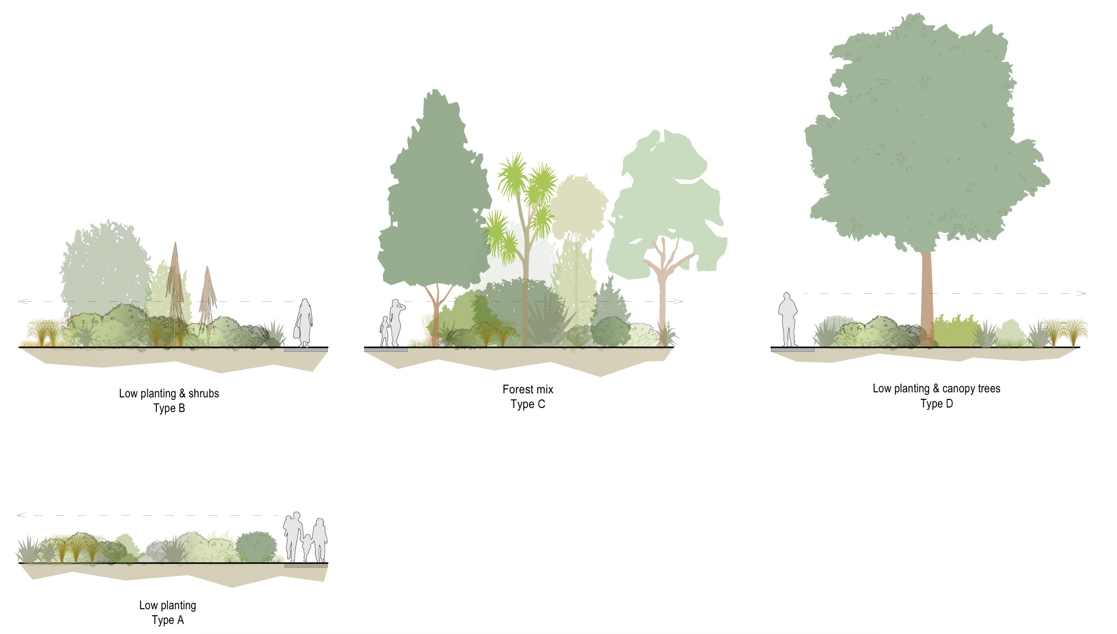
The four Plant Type Groups identified in the Planting Plan
- Type A – Low planting (max.1.2m height). This group primarily consists of plant species that flop over in a flood event. They also allow for good visibility of the river.
- Type B – Low planting and shrubs (max. height 6m), plus ti kōuka or similar. This group may incorporate harakeke, but it should be used sparingly, in clumps, and located away from the river edge, bridges and river narrowing, and from the edge of paths.
- Type C – Forest mix. These are plants suitable in combination to create a greater level of biodiversity, more akin with naturally occurring native bush.
- Type D – Low planting and canopy trees. Canopy trees are clear-trunked trees that allow sightlines beneath or allow for flood water to move around them, such as totara and kōwhai.
In addition to an explanation of the rationale for the plan, the Planting Plan for the Ōpāwaho Heathcote River includes 24 maps identifying locations that may be planted in one of the four Plant Groups. The plan is to go for approval to the Waihoro Spreydon-Cashmere-Heathcote Community Board in July and to the Waitai Coastal-Burwood-Linwood Community Board in August, after which any group wishing to plant on the riverbank will need to ensure that their planting conforms with the Planting Plan for the Ōpāwaho Heathcote River. (Note: This link is to the consultation version of the plan. We will update this to the final version when it is released.)
This should make it much easier, and legal, for groups of residents to work with their Community Partnership Ranger to help increase the canopy within the river corridor, and to help improve the ecological health of the river corridor.
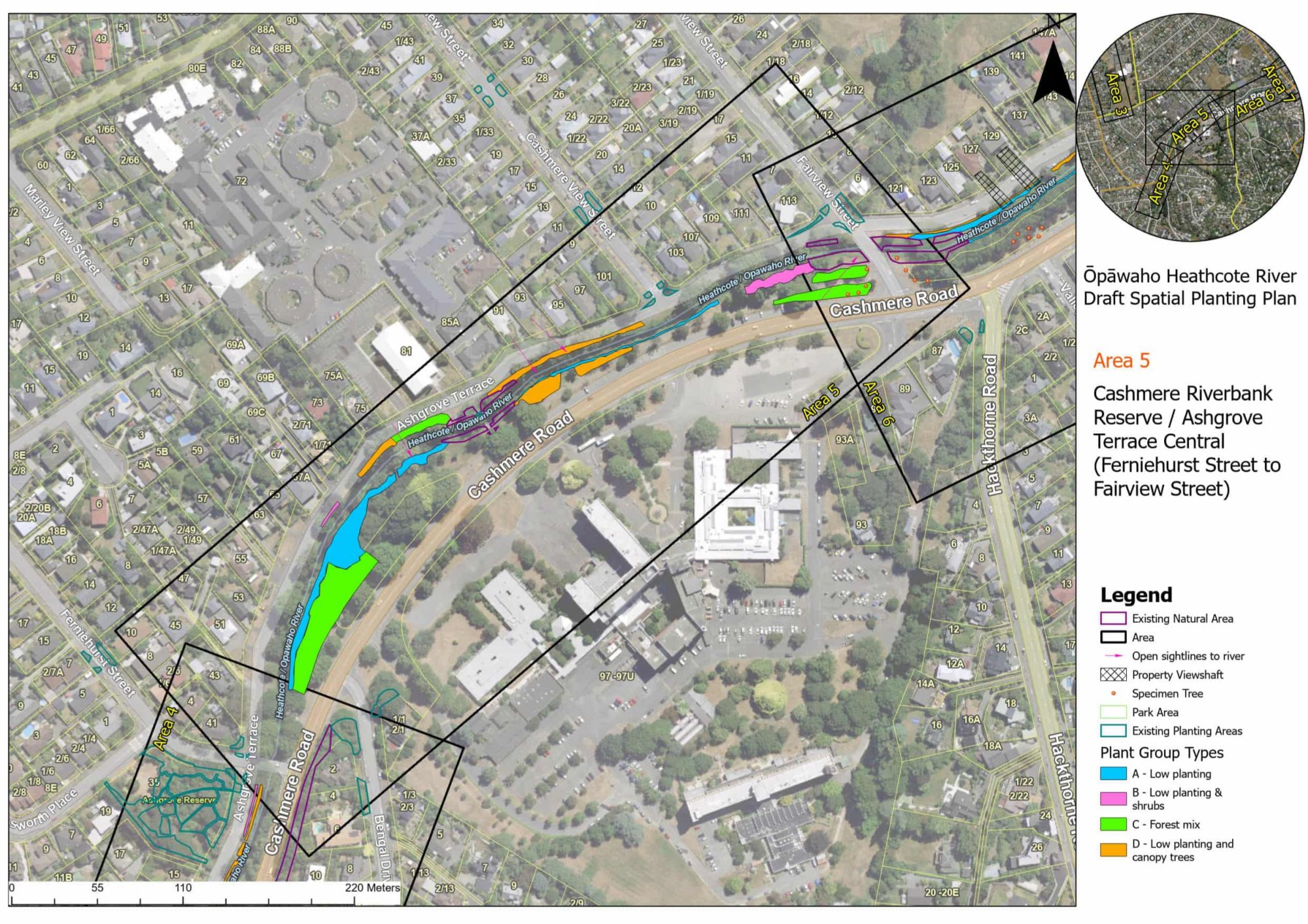
One of many maps showing areas that are able to be planted along the river with the type of plants indicated.