Waimōkihi Stream

Naming

This waterway appears on some older waterway plans as the “Cashmere Drain” or even on recent maps as the “Cashmere Brook”.  It is named in the CCC 3Waters maps on Canterbury Maps as “Waimōkihi Stream”. Waimōkihi more properly is a reference to the stretch of the Heathcote River upstream of the confluence.

In older maps and plans, the stream joining at its mid-point is the Wilderness Creek.  This creek is almost invisible now because of drainage systems.

Waimokihimap
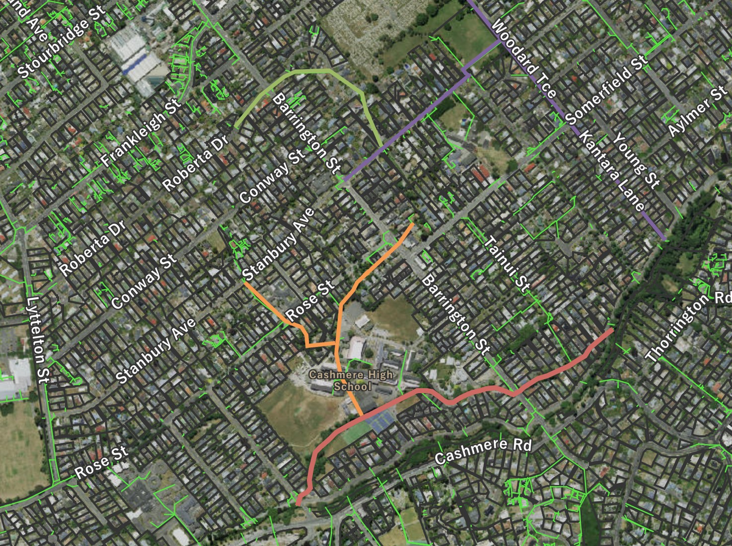
Waimōkihi Stream shown in red. The lower sections of what was Wilderness Creek are now piped (orange) while the top section of Wilderness Creek (light green) was diverted into a major drain (purple) called Wilderness Drain. Click to enlarge

Where it joins the river

Waimōkihi Stream
The culvert joining the stream to the river on Ashgrove Terrace. Click to enlarge
Img 2810
The outfall at the end of Fairview Street beside the bridge. Click to enlarge

About the waterway

1948waimokihi

1948 drainage plan shows original path of the streams. Click to enlarge

The level of flow throughout the year where this stream joins the river indicates that somewhere, probably in many places rather than just one, this stream is spring-fed.

If you look at the 1948 Drainage map, you can see the clear original path of the headwater stream.  This is Wilderness Creek the top part of which, early in the city’s drainage history, was diverted into a drain which was then named the Wilderness Drain.  The bottom part of the Wilderness Creek still drains into the middle of the Waimōkihi Stream (Cashmere Drain) inside the grounds of Cashmere High School but both sections are almost entirely piped and are not visible .

Unusually, Waimōkihi Stream has two outfalls into the river although, even close to Fairview Street, the stream flows away from Fairview Street towards the outfall opposite 259 Ashgrove Terrace.

The stream flows between private properties and through the grounds of Cashmere High School before being piped under Barrington Street and then beneath Ashgrove Terrace to enter the Ōpāwaho Heathcote River opposite the driveway to 259 Ashgrove Terrace. Generally, the bed of the stream is gravel/stones and the water is relatively sediment-free, even in high-rainfall events.

Cashmere High School student body has adopted the stretch of the waterway that runs through the school grounds for restoration planting on its banks.

Historical maps

1930s
Drainage Board plan from late 1930s.. Click to view original.
1948
A street map dated to circa 1948 with the waterways that contribute to the river clearly marked. Click to enlarge

A view of the waterway

Img 2809
A view of the cluvert under Fairview Street which takes the stream to the river although, even from this point, it appears that the stream flows away from this cluvert.. Click to enlarge
Img 2811
The stream enters the lower grounds of Cashmere High School. Click to enlarge
Img 2812
The stream passes behind the tennis courts of Cashmere High School. Click to enlarge
Img 2813
The revegetated section of the stream in the middle of Cashmere High School. It is in the midst of this section that the piped waterway joins it. Click to enlarge
Img 2785
A view of the creek as it passes in the culvert under Barrington Street. Click to enlarge
Img 2783
Some stretches are quite grassed to the edges. Click to enlarge
Img 2782
The creek passing along private property boundaries within formed walls of varying materials. Click to enlarge
Img 2781
The creek just as it enters the culvert under Ashgrove Terrace. This final section has naturalised banks. Click to enlarge