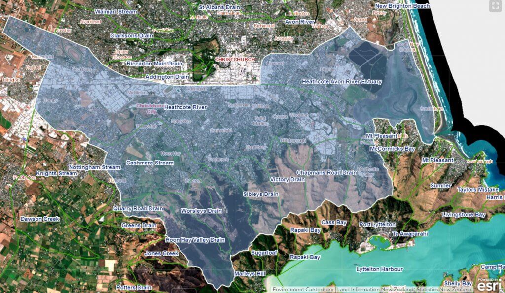
Location
The Ōpāwaho Heathcote River extends for approximately 25.5 km from south-west Christchurch to its mouth at Te Ihutai (Estuary of the Ōtākaro Avon and Ōpāwaho Heathcote Rivers) in Ferrymead. The catchment covers approximately 103 km² in the south of the city stretching north to south from the edge of the Central Business District to the top of the Port Hills and west to east from Ruapuna Park to the Ihutai Avon-Heathcote Estuary.
Naming
European settlers took little notice of the mana whenua names for the river. The settlers’ name for the river came from Sir William Heathcote, Secretary of the Canterbury Association, in London. At the time that it was named in Sir William’s honour, the river was in many places a meander through swamp and surface waters. It is therefore not surprising that the early settlers believed that the river took a right-angled turn where it met what is now Cashmere Road.
When the Cashmere Valley was drained to reveal the stream running through it, the landowner of the time, Sir John Cracroft-Wilson, named the revealed waterway Cashmere Stream. This set up the currently accepted but unofficial naming of the waterways as shown below.
However, for mana whenua, the waterway which provided food and transport over to Te Waihora (Lake Ellesmere) had the singular name Ōpāwaho, a reference to the outpost pā sited on the riverbank at the current site of the Opawa rail bridge. Joining Ōpāwaho at the confluence was a separate waterway called Waimōkihi. Waimōkihi refers to the area and Ōmōkihi refers to a pā site located in what today is called Centennial Park. Waimōkihi also denotes the probable usage of watercraft made of intricately bound raupo reeds. The mana whenua naming of the waterways is shown below.
This difference in the naming of waterways produces issues when it comes to dual naming.
- Naming the waterway from the coast to the confluence is straight-forward: Ōpāwaho/Heathcote River
- Confluence to Cashmere Valley: Ōpāwaho/Cashmere Stream
- Confluence to Nga Puna Wai and beyond: Waimōkihi/Heathcote River
If only the settlers had been more willing to accept mana whenua names for geographical features, this situation would not exist. From a geographic point of view, it is all in fact one waterway system. However, the water flowing downhill from the springs at Nga Puna Wai to meet the main stem of the river running along the base of the Port Hills means that the mana whenua naming convention makes more sense than the European one. Ngā Pou Taunaha o Aotearoa , the New Zealand Geographic Board has yet to be asked to officially determine names for the waterways.


